


Abkhazia (Georgia), the West Caucasus Mountains
ARABIKA MASSIF
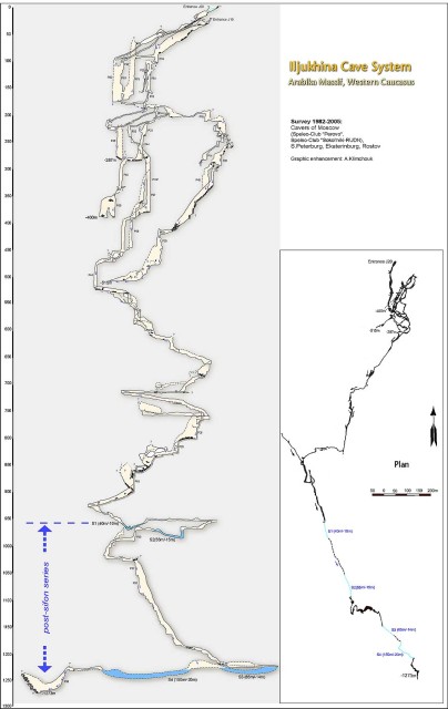
The cave system of V. Iljukhina (Iljukhinskaya)
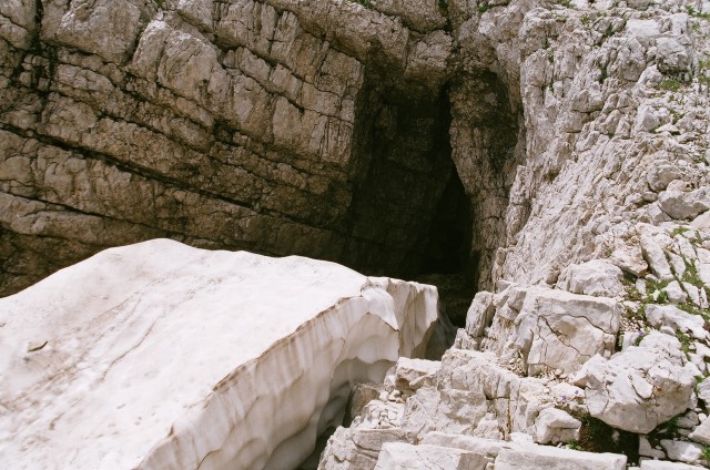
The entrance into Iljukhinskaya. Photo by Aidas Gudaitis
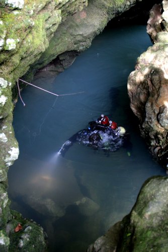
The cave system of Vladimira Iljukhina was discovered in 1980 and nowadays is one of the deepest hydro-geological systems in the world. Its main entrance is about 2400 m above the sea level. The temperature in the cave varies from 0 to 4 oC. Four difficult siphons have been discovered and dived through:
1st siphon: length 50m, depth 10 m, was dived through for the first time in 1985;
2nd siphon: length 70m, depth 17 m, was dived through for the first time in 1986;
3rd siphon: length 65m, depth 14 m, was dived through for the first time in 1987;
4th siphon: length 150m, depth 20 m, was dived through for the first time in 2005.
There are 3 stationary equipped underground camps in the cave. Currently the cave is explored by Moscow caving club "Sokolniki-RUDN".
The depth of Iljukhinskaya: -1273 m
Length: over 6 km
The scheme of the cave
The plan and profile of the part between siphons S2 and S3
The plan and profile of the part beyond the siphon S4
.jpg)
.jpg)
.jpg)
.jpg)
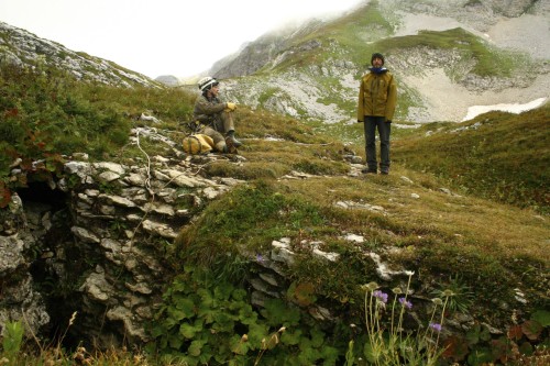
The photos from the expedition in 2006
The photos from the expedition in 2005
Krubera-Voronya
Jurga, Gintas and the entrance of Voronya. Photo by Aidas Gudaitis
The cave Voronya (aka Krubera-Voronya, Krubera cave, in Russian: Крубера-Воронья) by this moment is the deepest cave in the world. At this moment its depth is 2191 (±9) meters. It is the only cave in the world, deeper than 2 km. The entrance to the cave is 2256 meters above the sea level. The cave is located in the mountains of western Caucasus, Gagra range (Georgia), Arabika's massif. The cave belongs to the cave system of Arabika. The coordinates of the cave are 43° 24′ 35″ N, 40° 21′ 44″ E (http://en.wikipedia.org/wiki/Voronya_Cave).
Until 1983 Voronya was known by the name of Sibirskaya. In 1960 Georgian explorers found the entrance to this cave and explored it to the depth of "miserly" 95 meters. In the beginning of 80's the cave was explored to the depth of 340 meters and was forgotten for almost four decades. In 1999 intensive explorations were restarted when the Ukrainian speleologists on the depth of 230 meters found new passage, reached the depth of 700 meters and thus started a new era in the history of exploration of this cave.
For now the cave of Voronya is mostly explored by Ukrainian speleological association. In 2008 a team of three Lithuanians (Aidas Gudaitis, Gintautas Švedas and Jurgita Pekorienė) and Irish Stephen Macnamara joined the expedition of Ukrainians. During this expedition the team of caving club Aenigma installed water level gauges in the cave and thus started the project Towards the Center Of the Earth. In 2009 the main project's expedition was dedicated to the millenium of the name of Lithuania. Main achievements of the Millenary Expedition:
1. The data was taken from water level gauges installed in 2008 (at the depths of 1710 m and 1840 m), new gauges were installed at the depths of 1980 m and 2140 m. According to the data of the period from August, 2008 to August, 2009 water level has been raised for a maximum 13 meters.
2. Three cave divers Aidas Gudaitis, Gediminas Sakalauskas and Egidijus Purlys dived through the siphon Kvitotchka, reached the bottom of the cave and in the depth of 2140 m installed a sign of millenium of the name of Lithuania.
3. Lithuanian records of the deepest descent in the caves were broken: women record - the depth of 1440 m - was reached by Jurgita Pekorienė and Gintarė Šiaulytė, men record - the depth of 2140 m was reached by Aidas Gudaitis, Gediminas Sakalauskas and Egidijus Purlys.
4. Climbing started in 2008 at the depth of 1340 m in the Spanish branch was continued: 8 m deep pit was climbed up, followed by a small meander and a hall with two branches going up. Due to the discharged batteries further climbing was delayed.
Depth: -2191 m
The plan and the profile of the cave
Photos from the expedition in 2009 - project Towards the Center Of the Earth
Photos from expedition to Voronya in 2008. The diary of Stephen Macnamara from expedition in 2008
--------------------------------------------------------------------------
BZYB' MASSIF
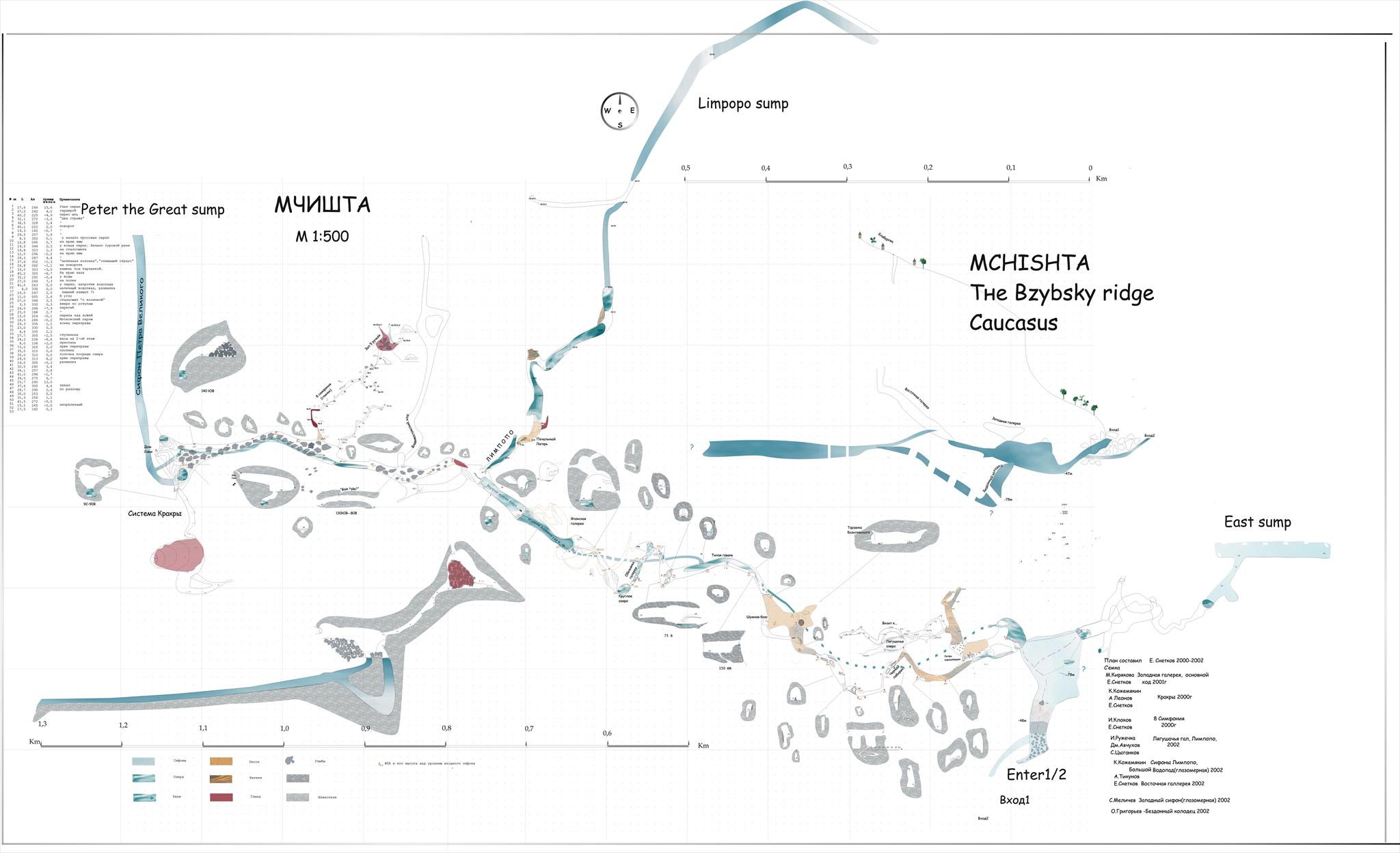
Mchishta
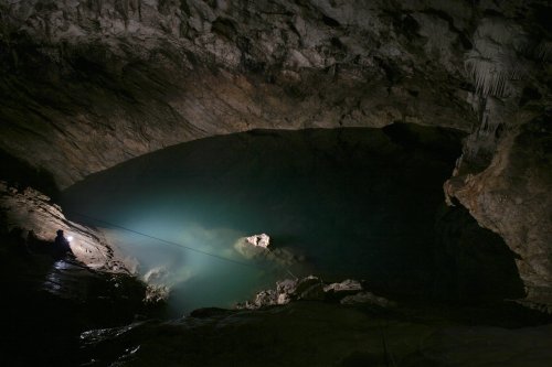
Entrance lake. Photo by Vidmantas Balkūnas
The river of Mchishta flows out of the cave bearing the same name and located on the ridge of Bzyb’ in the Caucasus, Georgia. This river-cave is the greatest karst spring in the Caucasus. Tides are often, up to 15-17 times per year. The water flows out of the cave through the obstruction of rocks stretching several hundred meters. The highest exit is a small lake (2 x 10 m) located under the rock. The water usually is muddy and the visibility is 1-2 meters (sometimes in the absence of tides the visibility can reach up to 7 meters). Nevertheless this cave is a perfect training base for cave divers. The cave siphons can be dived only with aqualung.
After the 250 meters long entrance siphon there is a sloping hall from where the cave branches into two passages heading westward and eastward. A huge hallway (total length of the passages is about 500 m) lies in the eastern part. At the end of this hall there is a partly explored siphon lake. Western gallery is more than 1,5 km long with average section of 20 x 20 m and goes along the main cave river. There are many sumps and other unexplored places in this passage.
Explored cave siphons: Entrance siphon (-44/250 m), Limpopo (-35/150+250 m).
Unexplored siphons: Deep Well (-83 m); Eastern siphon (-40/350 m); The Siphon of Peter the Great (-45/400 m); The Great Cascade (-20/100 m) – the exploration of this siphon is considered non-perspective.
Entrance siphon. Photo by Vidmantas Balkūnas.
The scheme of the cave
Photos from the expedition to the Mchishta cave in 2009